Item detail - Results
New Search
Report an error or omission in this item's data
New Search
| Item | 45690 |
|---|---|
| UDC Class: | 631.442(689.4) |
| Title: | Soils Map of the Republic of Zambia |
| Subtitle: | The Republic of Zambia Atlas Sheet No. 12. |
| Language: | English |
| Subjects: | Soils Classification, Soil Genesis, Parent Material, Soil Profile Description, Water Regime |
| Series Section Number: | Sheet No. 12 |
| Publication Date: | 1967 |
| Publisher’s Name: | Soils Section, Research Branch, Dept. of Agriculture, Zambia |
| Place of Publication: | Lusaka |
| Corporate Author: | Soils Section, Research Branch, Dept. of Agriculture, Zambia |
| Material Extent: | 1 map sheet |
| Material Characteristics: | Printed colour map with legend and descriptive text at the back of the map sheet. |
| Material Type: | Loose map in a plastic wallet |
| Summary Abstract: | Printed colour map, at 1:1,500,000 scale, showing the distribution of main soil types of Zambia. 8 main soils groups are identified and 17 soil types are mapped and described in the legend, according to the system used for the Soil Map of Africa (D'Hoore, 1964).25 representative soil profiles are described at the back of the map sheet, together with a table showing the analytical physicochemical data of the profiles.This map sheet No. 12 is the first published soil map of the country.The map sheet is found loose in a plastic wallet. |
| Country Now: | Zambia |
| Region: | East Africa |
| Nearest City: | Lusaka |
| Northernmost Latitude (decimal degrees): | -8 |
| Southernmost Latitude (decimal degrees): | -18 |
| Easternmost Longitude (decimal degrees): | 33.5 |
| Westernmost Longitude (decimal degrees): | 22 |
| Map Sheet: | No. 12 |
| Map Scale: | 1500000 |
| Document File: |  45690.JPG (20.96 Mb) 45690.JPG (20.96 Mb) |
| Thumbnail: | 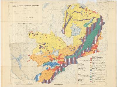 |
Report an error or omission in this item's data
New Search