Item detail - Results
New Search

Report an error or omission in this item's data
New Search
| Item | 43312 |
|---|---|
| UDC Class: | 631.474(669) |
| Title: | Vegetation and Land Use - Nigeria |
| Subtitle: | Sheet NB 32-1; 1:250,000 (Lokoja) |
| Language: | English |
| Subjects: | Vegetation Types, Land Use, Species, Scientific Names, Grassland, Shrubland, Woodland, Forest, Farmland, Plantations, Forest Reserves, Geomorphology Units, Administrative Units, Eco-Climatic Zones. |
| Series Title: | JOG 1501 |
| Publication Date: | 1978 |
| Publisher’s Name: | Federal Department of Forestry, Nigeria. |
| Place of Publication: | Lagos, Nigeria. |
| Project Sponsor: | Government of Nigeria, Ministry of Agriculture and Rural Development, Federal Department of Forestry. |
| Corporate Author: | Hunting Technical Services Ltd. |
| Material Extent: | One map; part of a set of sixty-nine Vegetation and Land Use maps of Nigeria. |
| Material Characteristics: | Printed colour map with legend, three inset schematic maps and index to adjoining sheets. |
| Material Accompanying: | Set of 250,000 scale Vegetation and Land Use maps of Nigeria, 1978. |
| Material Type: | Paper map with hanger frame in map cabinet |
| Summary Abstract: | This map forms part of a set of sixty nine, 1:250,000 scale, Vegetation and Land Use maps of Nigeria based on radar imagery, compiled by Hunting Technical Services Ltd. during 1976-1978. Map-Sheet NB 32-1 covers parts of the Benue, Bendel and Kwara States, and shows the distribution of twenty six Vegetation and Land Use Types, which are grouped into seven main Formations, including: Grassland, Wooded Shrub Grassland/Woodland Transition, Forest, Farmland, Plantations and Agricultural Projects, Mangrove, and Forest Reserves. On the map face there are, also, three inset schematic maps showing the location of Forest Reserves, Geomorphology Units, Administrative Units and Eco-Climatic Zones. See also Id. #20097 |
| Country Now: | Nigeria |
| Region: | West Africa; Benue, Bendel & Kwara States; Nigeria |
| Nearest City: | Lokoja |
| Northernmost Latitude (decimal degrees): | 8 |
| Southernmost Latitude (decimal degrees): | 7 |
| Easternmost Longitude (decimal degrees): | 7.5 |
| Westernmost Longitude (decimal degrees): | 6 |
| Map Sheet: | NB 32-1 |
| Map Scale: | 250000 |
| Document File: |  43312.jpg (39.00 Mb) 43312.jpg (39.00 Mb) |
| Thumbnail: | 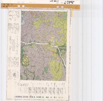 |
This item was acceeded to the WOSSAC archive from HTSPE Ltd. (now DAI), and is held at Cranfield University.
Report an error or omission in this item's data
New Search