Item detail - Results
New Search
Report an error or omission in this item's data
New Search
| Item | 2657 |
|---|---|
| UDC Class: | 631.474(673) |
| Title: | Reconhecimento da Baixa de Cassanje - Angola (Survey of the Lower Cassanje) |
| Subtitle: | Memorias e Trabalhos, No. 24 |
| Language: | Portuguese |
| Subjects: | Reconnaissance Soil Survey, Soil Classification, Soil Complexes, Catenary & Non-Catenary Complexes, Soiul Descriptions, Physiography, Topography, Geology, Climate, Land Suitability, Cotton. |
| Series Title: | Memorias e Trabalhos |
| Series Section Number: | No. 24 |
| Publication Date: | 1956 |
| Publisher’s Name: | Centro de Investigacao Cientifica Algodoeira |
| Place of Publication: | Lisbon, Portugal |
| Project Sponsor: | Centro de Investigacao Cientifica Algodoirra (Cotton Scientific Research Center) |
| Corporate Author: | Junta de Exportacao do Algodao and Centro de Investigacao Cientifica Algodeira |
| Author: | Gouveia, D.H.G. |
| Material Extent: | 200pp Report, including 27pp of photographs, plus 3 loose map sheets at the rear of the report. |
| Material Characteristics: | Printed report; with tables, figures, soil descriptions, 54 black & white photos, summary in English, list of references, and colour maps; one at 1:1M scale and two at 1:2M scale. |
| Material Accompanying: | Memorias e Trabalhos No. 24; 1956 |
| Material Type: | Perfect bound with printed cover |
| Summary Abstract: | This Report presents the findings of a soil survey undertaken in July & August 1954 in the Baixa Cassanje area, in the north-central region of Angola. The objective of the survey was to assess the suitability of the land for cotton production. The survey was carried-out at an exploratory and reconnaissance level; and the soil units identified were grouped into 33 soil complexes, which are broadly described in the report. Catenary and Non-catenary complexes were used as soil mapping units, and these are shown in the Preliminary Soil Map, at 1:1M scale, which is found at the rear of the report, together with two other maps, at 1:2M scale: Geological and Hypsometric maps. |
| Country Now: | Angola |
| Region: | South West Africa - Baixa Cassanje region, Angola |
| Nearest City: | Malange |
| Northernmost Latitude (decimal degrees): | -7.5 |
| Southernmost Latitude (decimal degrees): | -10.5 |
| Easternmost Longitude (decimal degrees): | 18.5 |
| Westernmost Longitude (decimal degrees): | 16 |
| Map Scale: | 1000000 |
| Document File: |  2657.JPG (5.99 Mb) 2657.JPG (5.99 Mb) |
| Thumbnail: | 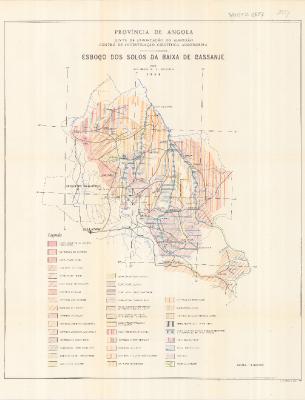 |
Report an error or omission in this item's data
New Search