Item detail - Results
New Search
Report an error or omission in this item's data
New Search
| Item | 1721 |
|---|---|
| UDC Class: | 631.473(673) |
| Title: | Carta Geral dos Solos de Angola (General Soil Map of Angola) - Memorias da Junta de Investigacoes do Ultramar No. 27 |
| Subtitle: | 2. Distrito de Huambo |
| Language: | Portuguese |
| Subjects: | Soil Survey, Soil Classification, Soil Groupings, Pedogenesis, Profile Descriptions, Physicochemical Characteristics, Analytical Data, Geomorphology, Topography, Geology, Vegetation, Climate. |
| Series Title: | Memorias da Junta de Investigacoes do Ultramar |
| Series Section Number: | No. 27 |
| Publication Date: | 1961 |
| Publisher’s Name: | Junta de Investigacoes do Ultramar (Overseas Research Council, Portugal) |
| Place of Publication: | Lisbon, Portugal |
| Project Sponsor: | Junta de Investigacoes do Ultramar - Portugal |
| Corporate Author: | Missao de Pedologia de Angola (Angola Pedological Mission) |
| Material Extent: | 282p Report, plus one map sheet |
| Material Characteristics: | Printed report; with tables, figures, colour illustrations, analytical data, profile descriptions, summary in English & French, list of references, and one colour soil map at 1:500,000 scale, at the rear of the report. |
| Material Accompanying: | Memoir No. 27 of the Overseas Research Council, 1961. |
| Material Type: | Perfect bound with printed cover |
| Summary Abstract: | This Report presents the findings of a study carried out by the Angola Pedological Mission (of the Portugal Overseas Research Council) designed to identify, classify and describe the main soils of the Huila District in the west central part of Angola. The field survey was undertaken during 1956. The Report, which is in the Portuguese language, includes the classification and description of six main Soil Groupings ("Agrupamentos"; soil units of categorical level below the great soil groups and close to the definition of soil series). For each of the Groupings; topographic, geological, botanical and climatic data is provided, and physicochemical and mineralogy of the clay fraction analytical data is given for 91 typical soil profiles. The Report is accompanied by a colour Soil Map, at 1:500,000 scale, with a comprehensive legend. This soil map of the Huambo District is the second sheet of the General Soil Map of Angola. See also WOSSAC Ids. #25486 and #42199 |
| Country Now: | Angola |
| Region: | South West Africa - Huambo District of Angola |
| Nearest City: | Huambo |
| Northernmost Latitude (decimal degrees): | -11.42 |
| Southernmost Latitude (decimal degrees): | -13.83 |
| Easternmost Longitude (decimal degrees): | 16.58 |
| Westernmost Longitude (decimal degrees): | 15 |
| Map Sheet: | Sheet 2 |
| Map Scale: | 500000 |
| Document File: |  1721.JPG (14.15 Mb) 1721.JPG (14.15 Mb) |
| Thumbnail: | 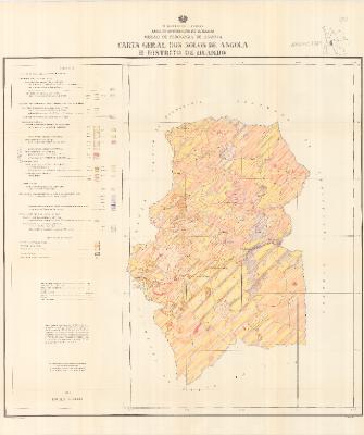 |
Report an error or omission in this item's data
New Search