Item detail - Results
New Search

Report an error or omission in this item's data
New Search
| Item | 999 |
|---|---|
| Title: | Land utilisation survey of Harpenden - 1966 |
| Subtitle: | Land utilisation |
| Language: | English |
| Subjects: | Agriculture, Land classification |
| Series Section Name: | Land utilisation survey of Harpenden - 1966 |
| Publication Date: | 1971 |
| Publisher’s Name: | NSRI |
| Place of Publication: | NSRI |
| Project Sponsor: | DEFRA |
| Material Extent: | Map |
| Material Characteristics: | Map |
| Material Type: | Map |
| Summary Abstract: | Land utilisation survey of Harpenden - 1966 |
| Country Now: | England (UK) |
| Map Sheet: | TL01 & TL 11 |
| Map Scale: | 25000 |
| Document File: |  999.jpg (6.58 Mb) 999.jpg (6.58 Mb) |
| Thumbnail: | 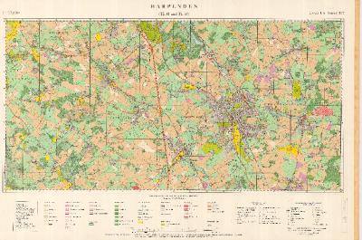 |
This item is part of the National Soil Reference collection held at Cranfield University. The collection underpins the Land Information System', or 'LandIS'
Report an error or omission in this item's data
New Search