Item detail - Results
New Search
Report an error or omission in this item's data
New Search
| Item | 47709 |
|---|---|
| UDC Class: | 631.442(914) |
| Collection reference: | NCAE |
| Title: | Soil Map of ILOILO Province, Philippines |
| Subtitle: | |
| Language: | English |
| Subjects: | Soil Survey, Soil Classification, Soil Types, Texture, Soil Structure & Consistency, Profile Diagrams |
| Series Title: | Provincial Reconnaissance Soil Surveys |
| Publication Date: | 1946 |
| Publisher’s Name: | Department of Agriculture and Natural Resources, Bureau of Soils, Manila |
| Place of Publication: | Manila |
| Project Sponsor: | Department of Agriculture and Natural Resources, Philippines |
| Corporate Author: | Bureau of Soils |
| Author: | Rosell, D.Z., et al |
| Material Extent: | One coloured map |
| Material Characteristics: | Printed colour map, at 1:250,000 scale, with soil legend, soil profile diagrams and conventional map signs. |
| Material Accompanying: | Soil Report No. 9 - Soil Report of Iloilo Province, Philippines, 1947 (at WOSSAC #41787) |
| Material Type: | Paper map |
| Summary Abstract: | A coloured map at scale 1:250,000, of Iloilo Province, dated 1946. The are four authors mentioned led by Rosell, D.Z. The map depicts the distribution of 19 Soil Type map units and, on the map face, shows 10 typical profile diagrams. The map includes the island of Guimaras. This map is likely to accompany the earlier report at #41787, dated 1947. |
| Country Now: | Philippines |
| Region: | South East Asia - Iloilo Province of Philippines |
| Nearest City: | Iloilo city |
| Northernmost Latitude (decimal degrees): | 11.666 |
| Southernmost Latitude (decimal degrees): | 10.333 |
| Easternmost Longitude (decimal degrees): | 123.42 |
| Westernmost Longitude (decimal degrees): | 122 |
| Map Sheet: | Iloilo Province |
| Map Scale: | 250000 |
| Document File: |  47709.jpg (15.72 Mb) 47709.jpg (15.72 Mb) |
| Thumbnail: | 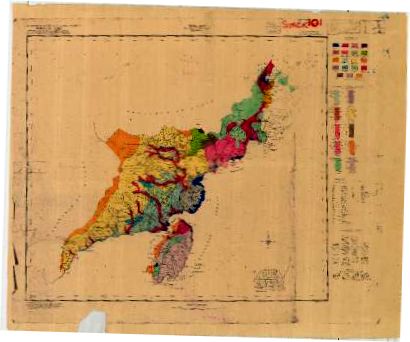 |
Report an error or omission in this item's data
New Search