Item detail - Results
New Search
Report an error or omission in this item's data
New Search
| Item | 47650 |
|---|---|
| Collection reference: | Second Land Utilisation Study |
| Title: | Scapes and Fringe Territories of Britain |
| Subtitle: | Environmental Territories of England and Wales - South |
| Language: | English |
| Publication Date: | 1981 |
| Publisher’s Name: | HMSO |
| Place of Publication: | Kings College, University of London |
| Author: | Alice Coleman |
| Material Characteristics: | A0 map sheet |
| Summary Abstract: | The Scape and Fringe Map is a summary of the land uses recorded by the Second Land Utilisation Survey. It has been synthesised from six-inch field maps showing 250 land-use categories, by means of a precise pattern-recognition technique which is explained in the accompanying book, 'Scape and Fringe Patterns of Britain'. |
| Country Now: | Great Britain |
| Map Scale: | 400000 |
| Document File: |  47650.jpg (23.51 Mb) 47650.jpg (23.51 Mb) |
| Thumbnail: | 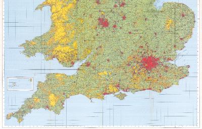 |
Report an error or omission in this item's data
New Search