Item detail - Results
New Search
Report an error or omission in this item's data
New Search
| Item | 47412 |
|---|---|
| UDC Class: | 631.442(73) |
| Title: | Generalized Soil Map of the Hawaiian Islands |
| Subtitle: | Legend Sheet |
| Language: | English |
| Subjects: | Soil Survey, Soil Classification, Soil Families, Soil Orders, Great Soil Groups |
| Series Title: | Generalized Soil Maps of the Hawaiian Islands |
| Publication Date: | 1954 |
| Publisher’s Name: | Hawaii Agricultural Experiment Station |
| Place of Publication: | Hawaii |
| Project Sponsor: | U.S. Department of Agriculture - Soil Conservation Service |
| Corporate Author: | USDA - Soil Conservation Service |
| Author: | Cline, M.G. and Foster, Z.C. |
| Material Extent: | One sheet |
| Material Characteristics: | Printed soil legend with coloured map units groupings and conventional map signs |
| Material Accompanying: | Generalized Soil Maps of the Hawaiian Islands |
| Material Type: | Paper sheet in a plastic wallet. |
| Summary Abstract: | This is the Legend to the series of six coloured Generalized Soil Maps, at reconnaissance scales, of the Hawaiian Islands, published in the 1950s by the USDA-Soil Conservation Service & the Hawaii Agricultural Experiment Station. The actual soil survey dates from 1935-39. These maps therefore date before the islands joined the USA. The separate Soil Legend, presents a list - with a brief description - of 104 Soil Families grouped into 15 Soil Orders/Great Soil Groups which are portrayed as coloured mapping units. See also WOSSAC Ids: #47386 #47406 #47407 #47408 #47409 #47410 #47411 |
| Country Then: | Hawaii |
| Country Now: | United States of America (USA) |
| Region: | North Pacific Ocean |
| Nearest City: | Honolulu |
| Northernmost Latitude (decimal degrees): | 22.4 |
| Southernmost Latitude (decimal degrees): | 18.8 |
| Easternmost Longitude (decimal degrees): | -154.75 |
| Westernmost Longitude (decimal degrees): | -159.85 |
| Map Scale: | 158400 |
| Document File: |  47412.jpg (2.11 Mb) 47412.jpg (2.11 Mb) |
| Thumbnail: | 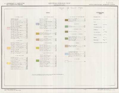 |
Report an error or omission in this item's data
New Search