Item detail - Results
New Search
Report an error or omission in this item's data
New Search
| Item | 47409 |
|---|---|
| UDC Class: | 631.442(73) |
| Title: | Generalized Soil Map of the Hawaiian Islands |
| Subtitle: | Island of Kauai - 1:134,000 |
| Language: | English |
| Subjects: | Soil Survey, Soil Classification, Soil Families, Soil Orders, Great Soil Groups |
| Series Title: | Generalized Soil Maps of the Hawaiian Islands |
| Publication Date: | 1954 |
| Publisher’s Name: | Hawaii Agricultural Experiment Station |
| Place of Publication: | Hawaii |
| Project Sponsor: | U.S. Department of Agriculture - Soil Conservation Service |
| Corporate Author: | USDA - Soil Conservation Service |
| Author: | Cline, M.G. and Foster, Z.C. |
| Material Extent: | One map sheet |
| Material Characteristics: | Printed colour map with soil legend on a separate sheet |
| Material Accompanying: | Generalized Soil Maps of the Hawaiian Islands |
| Material Type: | Paper map sheet in a plastic wallet. |
| Summary Abstract: | This map forms part of a set of six coloured Generalized Soil Maps, at different scales, of the Hawaiian Islands; which were prepared by the USDA-Soil Conservation Service & the Hawaii Agricultural Experiment Station. The actual soil survey dates from 1935-39; these maps therefore date before the islands joined the USA. This series is accompanied by a soil legend on a separate sheet archived as WOSSAC 47412, with coloured soil mapping units consisting of Soil Families grouped into 13 Great Soil Groups/Soil Orders. This map, at 1:134,000 scale, covers the Island of Kauai. There is also a separate coloured set of 20 soil maps at the scale of 1: 62,500 for the Hawaiian islands. See also WOSSAC Ids; #47386 #47412 |
| Country Then: | Hawaii |
| Country Now: | United States of America (USA) |
| Region: | North Pacific Ocean |
| Nearest City: | Kapaa |
| Northernmost Latitude (decimal degrees): | 22.25 |
| Southernmost Latitude (decimal degrees): | 21.85 |
| Easternmost Longitude (decimal degrees): | -159.25 |
| Westernmost Longitude (decimal degrees): | -159.83 |
| Map Scale: | 134000 |
| Document File: |  47409.jpg (5.94 Mb) 47409.jpg (5.94 Mb) |
| Thumbnail: | 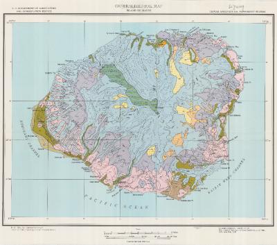 |
Report an error or omission in this item's data
New Search