Item detail - Results
New Search
Report an error or omission in this item's data
New Search
| Item | 47405 |
|---|---|
| UDC Class: | 631.442(73) |
| Title: | Soil Map of the Hawaiian Islands |
| Subtitle: | Island of Lanai - 1:62,500 |
| Language: | English |
| Subjects: | Soil Survey, Soil Classification, Soil Associations, Soil Series |
| Series Title: | Soil Maps of the Hawaiian Islands |
| Publication Date: | 1954 |
| Publisher’s Name: | Hawaii Agricultural Experiment Station |
| Place of Publication: | Hawaii |
| Project Sponsor: | U.S. Department of Agriculture |
| Corporate Author: | USDA - Soil Conservation Service |
| Author: | Ableiter Kenneth, et al. |
| Material Extent: | One map sheet |
| Material Characteristics: | Printed colour map with soil legend on a separate sheet |
| Material Accompanying: | Soil Maps of the Hawaiian Islands |
| Material Type: | Paper map sheet in a plastic wallet. |
| Summary Abstract: | This map forms part of a series of coloured soil maps, at scale 1:62,500, published in the 1950s, covering the Hawaiian Islands. The actual soil survey dates from 1935-39. These maps therefore date before the islands joined the USA. The maps were published by the USDA - Soil Conservation Service. This single map sheet covers the Island of Lanai. The soil legend is on a separate sheet, archived as WOSSAC 47376, with coloured soil mapping units which are grouped together as Soil Associations. These Associations combine Topographic and Soil Series which are listed and described in the legend. See also WOSSAC Ids: #47376 |
| Country Then: | Hawaii |
| Country Now: | United States of America (USA) |
| Region: | North Pacific Ocean |
| Nearest City: | Lanai City |
| Northernmost Latitude (decimal degrees): | 20.94 |
| Southernmost Latitude (decimal degrees): | 20.72 |
| Easternmost Longitude (decimal degrees): | -156.8 |
| Westernmost Longitude (decimal degrees): | -157.07 |
| Map Scale: | 62500 |
| Document File: |  47405.jpg (5.62 Mb) 47405.jpg (5.62 Mb) |
| Thumbnail: | 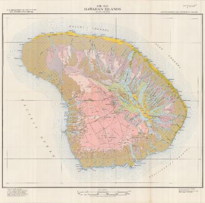 |
Report an error or omission in this item's data
New Search