Item detail - Results
New Search
Report an error or omission in this item's data
New Search
| Item | 47386 |
|---|---|
| UDC Class: | 631.442(73) |
| Title: | Generalized Soil Map of the Hawaiian Islands |
| Subtitle: | Soil Families of Hawaiian Islands Explanatory Table |
| Language: | English |
| Subjects: | Soil Survey, Soil Classification, Soil Families, Modal Profiles, Soil Orders, Great Soil Groups, Environment |
| Series Title: | Soil Maps of the Hawaiian Islands - Generalized Soil Maps |
| Publication Date: | 1954 |
| Publisher’s Name: | Hawaii Agricultural Experiment Station |
| Place of Publication: | Hawaii |
| Project Sponsor: | U.S. Department of Agriculture - Soil Conservation Service |
| Corporate Author: | USDA - Soil Conservation Service |
| Author: | Cline, M.G and Foster, Z.C. |
| Material Extent: | One sheet |
| Material Characteristics: | Printed, black & white, explanatory table |
| Material Accompanying: | Generalized Soil Map of the Hawaiian Islands |
| Material Type: | Paper sheet in a plastic wallet. |
| Summary Abstract: | This is an Explanatory Table ("Key, classification, modal profile, and environment for soil families of Hawaii") which groups soils into families which are characterised by modal profiles. The Table accompanies the Generalized Soil Maps of the Hawaiian Island, at different scales, and the corresponding Soil Legend which is at WOSSAC #47412. There is also a legend (at #47376) and a series of 20 coloured soil maps at scale 1: 62,500, published in the 1950s. by the USDA. The actual soil survey dates from 1935-39. These maps therefore date before the islands joined the US. The maps were published by the USDA - Soil Conservation Service and the Hawaii Agricultural Experiment Station. |
| Country Then: | Hawaii |
| Country Now: | United States of America (USA) |
| Region: | North Pacific Ocean |
| Nearest City: | Honolulu |
| Document File: |  47386.jpg (16.86 Mb) 47386.jpg (16.86 Mb) |
| Thumbnail: | 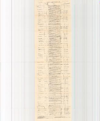 |
Report an error or omission in this item's data
New Search