Item detail - Results
New Search
Report an error or omission in this item's data
New Search
| Item | 45908 |
|---|---|
| UDC Class: | 631.442(729.5) |
| Title: | Soil Map of Puerto Rico |
| Subtitle: | West-Central Sheet |
| Language: | English |
| Subjects: | Soil Classification, Soil Types, Soil Groups, Physiographic Units, Profile Characteristics |
| Publication Date: | 1936 |
| Publisher’s Name: | University of Puerto Rico Agricultural Experiment Station |
| Place of Publication: | San Juan |
| Project Sponsor: | U.S. Department of Agriculture and University of Puerto Rico |
| Corporate Author: | USDA Bureau of Chemistry and Soils |
| Author: | Roberts, R. C., et al |
| Material Extent: | One map sheet |
| Material Characteristics: | Printed colour map with legend |
| Material Accompanying: | One of four in collection |
| Material Type: | Map sheet with hanger frame in map cabinet |
| Summary Abstract: | This sheet is one of a set of four soil maps covering the whole of the country of Puerto Rico.This printed colour map, at 1:50,000 scale, covers the West-Central part of the country.The map shows 46 soil mapping units which are arranged into 12 main soil groups based, mainly, on their association with specific physiographic units, and with additional information on texture, soil depth and parent material.See also Wossac Ids 45907, 45909 and 45910Note that this map is a duplicate of Wossac Id 45885 |
| Country Now: | Puerto Rico |
| Region: | Caribbean |
| Nearest City: | Ponce |
| Northernmost Latitude (decimal degrees): | 18.5 |
| Southernmost Latitude (decimal degrees): | 17.95 |
| Easternmost Longitude (decimal degrees): | -66.416 |
| Westernmost Longitude (decimal degrees): | -66.833 |
| Map Sheet: | West-Central Sheet |
| Map Scale: | 50000 |
| Document File: |  45908.jpg (14.63 Mb) 45908.jpg (14.63 Mb) |
| Thumbnail: | 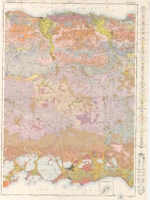 |
Report an error or omission in this item's data
New Search