Item detail - Results
New Search
Report an error or omission in this item's data
New Search
| Item | 44922 |
|---|---|
| UDC Class: | 631.473 (678) |
| Title: | Provisional Soil Map of East Africa (Tanganyika) |
| Subtitle: | |
| Language: | English |
| Subjects: | Catena, Soil map |
| Publication Date: | 1936 |
| Publisher’s Name: | Department of Agriculture |
| Place of Publication: | Amani, Tanganyika |
| Project Sponsor: | Government of Tanganyika |
| Author: | G.Milne |
| Material Extent: | Single sheet map with text |
| Material Characteristics: | Hand drawn map and hand written text |
| Material Type: | Single sheet in pocket folder |
| Summary Abstract: | The soil map highlights 4 areas in Tanganyika mapped as Catena Associations. These are Catena are shown as N.W. Bakoba, Tabora, Usukuma and Ugalla River Basin. The accompanying text is a note on Plateau Soils, Red Earths and Black or Gray Clay.This map can be seen in colour in the 1948 Atlas of Tanganyika, Sheet #4. The Notes in the Atlas are more comprehensive. |
| Country Then: | Tanganyika |
| Country Now: | Tanzania |
| Northernmost Latitude (decimal degrees): | -0.5 |
| Southernmost Latitude (decimal degrees): | -12.1 |
| Easternmost Longitude (decimal degrees): | 40.1 |
| Westernmost Longitude (decimal degrees): | 28.5 |
| Map Scale: | 4000000 |
| Document File: |  44922_Tanganyika_1936_800dpi.JPG (8.97 Mb) 44922_Tanganyika_1936_800dpi.JPG (8.97 Mb) |
| Thumbnail: | 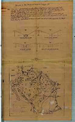 |
Report an error or omission in this item's data
New Search