Item detail - Results
New Search
Report an error or omission in this item's data
New Search
| Item | 35007 |
|---|---|
| UDC Class: | 631.47 (881) |
| Title: | Report on the Soil Survey project British Guiana |
| Subtitle: | Volume III: Reconnaissance soil Survey. Part 1 |
| Language: | English |
| Subjects: | Traditional reconnaissance soiil survey in two parts covering all of the country |
| Series Section Number: | FAO/SF:19/BRG |
| Publication Date: | 1964 |
| Publisher’s Name: | FAO |
| Place of Publication: | Rome |
| Project Sponsor: | UN Special Fund |
| Material Extent: | 137pp |
| Material Characteristics: | perfect Bound with map folder at rear. |
| Material Accompanying: | Five maps |
| Summary Abstract: | Coloured maps of North East, North West Guyana and SE and SW; plus one special map of the Pakaraima Mountains. |
| Country Then: | British Guiana |
| Country Now: | Guyana |
| Region: | South America |
| Nearest City: | Georgetown |
| Northernmost Latitude (decimal degrees): | 8.4 |
| Southernmost Latitude (decimal degrees): | 1.15 |
| Easternmost Longitude (decimal degrees): | -56.5 |
| Westernmost Longitude (decimal degrees): | -61.4 |
| Map Scale: | 5000000 |
| Document File: |  35007.zip (81.32 Mb) 35007.zip (81.32 Mb) |
| Thumbnail: | 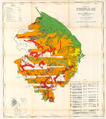 |
Report an error or omission in this item's data
New Search