Item detail - Results
New Search
Report an error or omission in this item's data
New Search
| Item | 24491 |
|---|---|
| UDC Class: | 631.473 (412) |
| Title: | Soil map of Wrest Park, Silsoe, Bedfordshire |
| Subtitle: | Soil survey of the grounds of the National Institute of Agricultural Botany(NIAB), Silsoe, Bedfordshire. Accompanied by soil profile descriptions. |
| Language: | English |
| Publication Date: | 1945 |
| Publisher’s Name: | Ministry of Works, Cambridge |
| Project Sponsor: | Mr Stokes or Mr Miller at Wrest Park |
| Author: | W.G.D. Walters |
| Material Extent: | 47cm x 33cm map sheet folded plus hand written notes |
| Material Accompanying: | Loose sheets and cards |
| Summary Abstract: | Soil survey of the Wrest Park grounds - unpublished. Marked "Cambridge District 2, Job No. 512, L.E.N. 16/6/1945". This survey was commissioned prior to the opening of the (NIAE), National Institute of Agricultural Engineering at the Silsoe location. The map is dated June 1945. The location of 137 bores is marked and a clear line demarcates the boundary between the greensand geology to the north and and the Gault clay to the south. The site was selected in order to provide contrasting soils for agric experimentation. There are also handwritten notes on soil bores at the site.Accompanying sheets relate to surveys in Bedfordshire's King's Wood (Near Ampthill) and the Brickhills (villages nearby). |
| Country Now: | England (UK) |
| Region: | Bedfordshire, England |
| Map Scale: | 63360 |
| Document File: |  24491.jpg (0.87 Mb) 24491.jpg (0.87 Mb) |
| Thumbnail: | 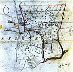 |
Report an error or omission in this item's data
New Search