Item detail - Results
New Search

Report an error or omission in this item's data
New Search
| Item | 20286 |
|---|---|
| Collection reference: | HTSPE00286 |
| Title: | Tanzania Land Cover and Land Use |
| Subtitle: | Lake Manyara |
| Language: | English |
| Series Title: | Land Cover & Land Use |
| Series Section Number: | Sheet SA-36-16 |
| Series Section Name: | Lake Manyara |
| Publication Date: | 1996 |
| Project Sponsor: | Tanzania Ministry of Natural Resources and Tourism |
| Corporate Author: | Hunting Technical Services |
| Material Type: | Good |
| Summary Abstract: | This sheet is part of an extensive assessment of land cover and land use in Tanzania carried out by HTS in the mid 1990s. Remote sensing image interpretation was supported by field work, and the published scale is 1:250,000. Maps are coloured and there is a detailed legend on the face of each map. All maps are scanned . Thee is a second set in the map draweres in B121Upper |
| Country Now: | Tanzania |
| Northernmost Latitude (decimal degrees): | -3 |
| Southernmost Latitude (decimal degrees): | -4 |
| Easternmost Longitude (decimal degrees): | 36 |
| Westernmost Longitude (decimal degrees): | 34.5 |
| Map Scale: | 250000 |
| Document File: |  20286.zip (46.52 Mb) 20286.zip (46.52 Mb) |
| Thumbnail: | 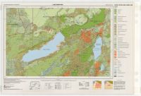 |
| KMZ File: (Google Earth) | 20286.kmz (3.86 Mb) |
This item was acceeded to the WOSSAC archive from HTSPE Ltd. (now DAI), and is held at Cranfield University.
Report an error or omission in this item's data
New Search